I had my yearly exam appointment scheduled at the VA Clinic in Portland for August 19th and a reservation at Rolling Hills RV Park so left Walla Walla on the 17th. Took the same route I came in on and this time stopped a time or two for pictures since it’s only a 4 hour drive and I had plenty of time. This time I didn’t take the Bend turnoff of course but continued straight west on I-84. Stopped at Multnomah Falls for a short visit too.
And here I am on highway 12 just outside of Walla Walla…wanted to show how brown it is here most of the year. With a splash of green presented by the grape fields off in the distance. Which reminds me…Walla Walla now has something over 200 vintners in the area. The weather and soil is much like the wine area of France. They’re all over the place.
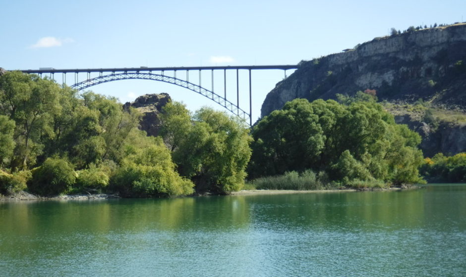
 And than I pass the mighty Columbia. This is where it makes a sharp turn and flows through the Wallula Gap. Look at all that water though. This is why California tried for decades to get water rights to this river. Ain’t gonna happen.

 Over there are the foothills of the Horse Heaven Hills. That row of trees is a farmer’s windbreak. Been there for decades and the trees are quite mature now.
 Railroad tracks over there. On this side of the river too.
 Lots of water.
 I grew up around here so I love this area. Isn’t hard to see why it’s a National Scenic area either.
 Halfway up the Columbia River gorge, I got off the freeway and wandered along the old river road. It climbs quickly. This serpentine section is by no means unique. You’ll find them along the entire old highway route here in the gorge. The master road designer planned it that way. But it was in an era when cars only traveled 15-25 MPH too.
 Down there is I-84 and this view gives you a idea of how rugged the gorge is. Note also the striations on the sides of the hills on either side, though they’re easier to spot on the left side in this picture. Those are scour lines left by the floods. Imagine the water being that deep.
 A little town over on the Washington side. You can see where the hillsides gave way and sloughed off the hills and created a nearly flat area approaching the river. Might have been earthquake caused. Or perhaps rain for weeks followed by heavy wet snow. Who knows?
 Here’s where I was for the above pictures.
 Kind of pretty here.
 Even more striations in the hillsides visible from here. This point I’m on was under another 20-30 feet of water during some of the floods. And dry other times.
 That’s the old two lane Columbia River highway on the Washington side. Couple of older bridges built in the 1940’s.
 But is was soon time to wander off. Heading west.

 Back down on the interstate, there’s Crown Point in the distance I think…maybe…[On Edit: I’m told that is probably Rooster Rock and that Crown Point is further west.]
 And since it was still early in the day, had time to stop at Multnomah Falls for a brief respite.
 And here it is. Not too crowded today. Thankfully.
 There use to be a wooden platform up there. Don’t know what happened to it. I’ll have to find out next trip. Lots of dogs fell to their deaths from there because it was built to 1930’s style safety standards. Some people fell or jumped from there too.

And soon after visiting the falls, like 30 minutes later, I was parked and hooked up at the RV park behind Stagecoach. The next night was Taco Tuesday. Yum. Day after that, went into the VA clinic for my yearly checkup. Next afternoon headed over to my friends house to house sit for them while they went and visited family in Philadelphia. And that’s where I’ll pick up next time. See you then!
The wife and I took a leisurely drive up the Old Gorge Highway on Easter in 2014. Hadn’t done that for awhile. Last time I think was 30 years ago in the ’84 Pace Arrow when I tweaked our entry step on a roadside outcropping while rounding a narrow turn eastbound – lesson learned. The Old Highway is no place for RVs larger than class B, at least not in the western sections where all the waterfalls are – the road was built for Model T’s (what the Sam Hill? -inside joke). As Jim knows, it’s pegged essentially into steep gorge cliffsides, hence all the waterfalls, and is replete with tunnels where builders opted to go through vertical rock obstructions rather than hang the road precariously from them. Between The Dalles and Mosier the Old Highway is a little different story, albeit still winding in spots, negotiating long routes around the occasional escarpment, and following rolling hills and lazy ravines.
We really enjoyed the auto trip that Easter – minimal wind, lots of warm sun but not hot, and wildflowers starting up, not to mention blossom time for the fruit trees at Hood River. But I didn’t recall ever being at the Rowena lookout, so that was particularly a treat. The roadbuilding history described at sites along the route was really enjoyable. Negotiating that very deliberately and carefully planned and built hairpin at Rowena is a relatively mundane experience compared to looking down on it from the viewpoint above – spectacular. Thanks for the reminder photo!
The burg across the river from Rowena is Lyle, Washington. And the outcropping in the one photo further on isn’t Crown Point, which is further west, just east of Corbett, and likely visible as you traveled past Rooster Rock or as you left Multnomah Falls going west.
Traveling the gorge was a once, twice a year activity the family did back when we all lived in Gresham. But you know how it is, as the years pass, it becomes passe’ and soon it’s only once every 2-3 years. Now that I’m driving around in a big RV, I still wander through areas of the gorge on the old highway. It’s not all that bad for a big Class A. BTW, I use to love going to Char Burger in Cascade Locks under the Bridge of the Gods but this trip when I went to stop there, the parking lot was packed. Nowhere to park my rig. And the names been changed. Place has been sold I guess.
I’ve been through Lyle many times over the years but never stopped and never had a reason to remember the name. Now, Goldendale I remember. Almost got killed there one winter from snow on the ground, bald tires, and a fast approaching road grader blade heading right towards me in my slipping/sliding Toyota. Yikes! Went and bought a new set of tires the next day at my home base of Yakima (I’d just gotten a job in Portland and came home on weekends). Had a fight with the wife about frivolous spending. Finally convinced her that almost getting killed was pretty damned good reason for a new set of tires.
After I published this entry, I did realize that that point wasn’t Crown Point, but I haven’t bothered to change it. Maybe I’ll do that today…thanks for giving me a likely name!