Chihuahua state Mexico – Jan. '10

The quota road south of Chihuahua is in excellent shape and I had an easy day of it. I was a little worried about my trip plans for the day because to reach the only available RV park in Lardo, I had to negotiate some difficult narrow roads and sharp turns right in the middle of that big town. Then the park was really just a hotel with some 15amp outlets where they often forgot about the RV’ers and turned off the outlets when they closed for the night. And their price seemed a little high for the facilities and the crowded, probably noisy, area. Just a parking lot really, according to the guide book. But I had committed my brain to staying there so it came as a surprise that I got to the decision-to-enter-the-city-or-not point so early in the day, shortly before 2pm, when I prefer to travel to 5pm. Well, it’s an adventure so I passed the turnoff to the hotel and crossed my fingers that I’d be able to find a RV park in Zacatecas. I figured if I couldn’t, I could always stay at another 24 hour Pemex. According to my calculations, I should be able to get there before 7pm, it was the time of year that dusk occurred at 6:30pm. I didn’t care to be driving in Mexico in the dark but I felt a Pemex would be available just before town.

But after around 60 miles I’m shocked to discover that I’d missed my turn onto Mex 49 and was heading toward Durango instead of Zacatecas! I’d stayed on Mex 40 instead of taking the Mex 49 ramp. My laptop on the dash had yelled at me, ‘Off Route’, several times but I’d ignored it’s pleas until it calculated a new route and shut up. I had no plans to go to Durango, it was not anywhere in my pre-arranged destination maps in MS Streets & Trips and I didn’t know anything about RV parks there but here I was heading for it. When I discovered my error, I was too far along to turn back so crossed my fingers and hoped there would be a place to stay for the night.

Late in the day, around 5:30, I come upon a nice 24 hour Pemex just outside Durango and just a couple miles from a turn off that I now knew would be the road I’d need to take the next morning. I filled up and got help from the attendant to get cash from my debit card, which wasn’t working at the ATM machine. This happens sometimes in Mexico since the ATM’s are not all tied into each others networks. What the attendant did was have me pay for my diesel first (the Pemex system took my card fine) then had the gal rerun it for another $400 pesos. Then he took that paper and kept it but handed me the $400. Now with cash, I could get some dinner. I already had a little but not enough to be comfortable if I needed fuel at a Pemex that only took cash.

The Pemex was so convenient I didn’t even need to go into town. Nice restroom, a store, and a restaurant. And the weather wasn’t very nice,  not the kind of day to walk around town, so I parked with the truckers. Ate a nice dinner in the little restaurant there for $70 pesos and wandered around for a bit. Came back to the RV and recalculated a new route to Guadalajara from Durango. While doing that I found that the accidental Durango excursion would add 70 miles to my trip. Couldn’t really find anything in the guidebooks about Durango that was very interesting so didn’t feel any need to visit. Turned in at 10pm and read for a couple hours. I don’t use the heat usually because of the energy used makes it a hassle but I do have two heavy blankets to keep warm. It is pretty cool in the evenings here, dipping down to 40°F at night but getting up to 75°F during the day. I am in the mountains and that’s not a surprise, though many I’ve talked to about Mexico think that the entire country is hot all  the time. Not true.

On the way south, even more gloomy clouds.

That morning was dark and cold. But little rain fell on me this portion of the trip.

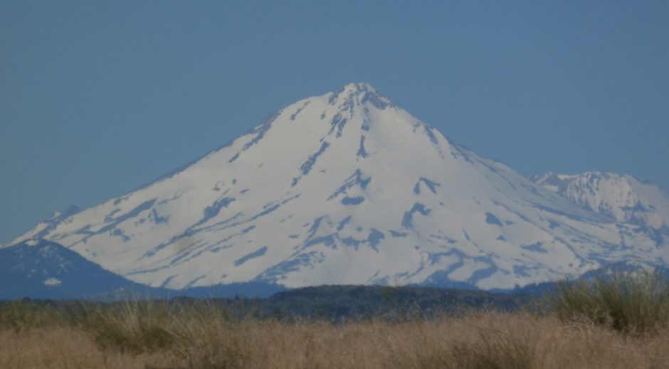
I’m around 4500 feet where the above picture was taken. It’s a four lane highway with few villages along the way. It’s surprising considering how good the countryside looks, I’d have expected many villages along the way but that wasn’t the case. But the towns I passed, like Chihuahua, were huge, spreading out over vast areas. But they have lots of room, so, no worries.

Here I am parked with the truckers around 6pm.

As night fell, more and more trucks eventually boxed me in so I couldn’t have gone anywhere if I’d wanted to. But that’s OK, I wasn’t in that big of a hurry anyway, though the next day I’d be getting to Guadalajara late in the day, I felt I had it under control with a S&T map showing a new route.

Next morning, dew drips off the RV. And there is almost room for me to get out.

I was boxed in pretty well, so I had to back up 60-80 feet to get out of there but a couple Mexican drivers were behind me talking so they gave me directions during the maneuvers.

One of the small villages along the road south.

Finally, some nice weather. But I'm at 6,000 feet here. Can't last.

Ahh, there we go...snow on the ground. At this point I'm at 7700 feet.

Heading towards Guadalajara I kept getting higher and higher (the GPS sensor shows altitude), and it kept getting colder and colder. Storm clouds kept rolling in and I began to wonder if I shouldn’t have just gone down the west coast to Mazatlan and enjoyed balmy weather instead?

Eventually, I got to Guadalajara and sure enough, the poor road signs and MS S&T led me astray so I got lost and ended going close to downtown. One of the guide book warnings was to stay on the periferico around the city, what there is of it, because the Guad cops like to ticket RV’s for being in the wrong place. Guad doesn’t have a circle road all the way around like most Mexican towns do so I must have missed an exit or something. I was trying to skirt the town by following the Airport signs but that was only a minor help. Eventually, the S&T program with the GPS got me on the right road (after putting me on the wrong one to begin with) and I headed south of town trying to find the San Jose RV Park. Because of the trouble, I got there around 5:30 and there was a fiesta going on around the couple of small restaurants that are there on the park grounds so I got boxed in by cars and confused by the lack of signs and made a turn onto the road that went to the exit. The highway was one way, I hadn’t found the entrance to the park, but I did see signs that indicated I was in the right place, the only road that could have been the entrance was marked ‘Private’, and since I thought I knew where the next park was, I just skipped trying to loop around to find the San Jose park and headed out of town towards the Chimulco Trailer Park in Villa Corona. Now my GPS program was doing well and I followed that as it got dark.

What I didn’t know was that the program was leading me to the wrong place…as given me by the park. I’d emailed them about what were incorrect GPS coordinates in my guide book, I could tell from the map that they put me in the middle of a town but the description did not say that would happen, and they sent back what they said were GPS coordinates from Google Earth. Well, when plugged into the mapping program they did take me up a road, not to the middle of a field so I trusted them. Although it was dark, I kept on until I got where S&T sent me and found…nothing but a power relay station. No houses, no RV park, no street lights, no traffic, out in the boondocks. In the dark, in Mexico.

Well, thinking it was just a mile or two beyond, I headed up the road and could see the lights of a small village against the hills off in the distance. I knew I was not going to find the RV park there. So I looked for a turn around spot. When I found it, I turned in, started to back up across the narrow two lane road and felt the RV sink in the back end. Aware of the dangerous cliffs next to roads all over Mexico, I jump out of the RV and ran back and looked…too dark to be sure of anything, and I didn’t want to attempt backing up any further. I’d already tried to drive out and couldn’t so I just grabbed my flashlight and waved down the cars that started to arrive, guiding them around the front of the RV.  One guy stopped and told me in English that he’d come back to help. Then the traffic started to get heavy and it’s all I can do to keep it moving around the front of the RV where there was just enough room for one vehicle at a time.

Then two guys in a pickup pull up and offered to help. One of the guys spoke English and he started directing traffic while his friend wandered back to the back of my still running rig to check things out. My flashlight was growing dim so I asked the guy if he could call a tow truck, a big one, and the cops to direct traffic. He did and let me know that the tow truck would take 2 hours to get there and the cops in a half hour. About that time I started to smell something burning and worried that the engine heat was starting the tall grass near the rear of the rig on fire. That’s all I needed, to burn up my RV. While I was looking for flames the friend poking around the back came up and told us that I could back up some more, that it was flat back there…to get a run at getting the RV up the ledge along the side of the road. The other guy volunteered to try it, jumped in the drivers seat and with my directions for shifting, worried the RV up the incline and over into the turn around spot. There we parked for a few minutes while all the traffic cleared both lanes and it grew dark & quiet again. I asked him where all those people came from all of a sudden and he tells me that a big race had just finished and everyone was going home. Just my luck. I explain I’m looking for an RV park and he tells me to follow him, it’s only 5 kilometers away.

Off we go to Villa Corona and they stop at a turn and tell me to go to the ‘T’ turn right and it’s up the road. Not ‘just up the road’ but ‘up the road’. I should have asked because I thought it was 3-4 miles. They also mentioned it would probably be closed now that it was 8:30 or so. Well, I tried to find it in the darkness, but drove by the place and went beyond by 3 miles, turning in a steep driveway, the RV slowwwwwly climbing back up the driveways hill making me sweat a little. Who wants to get stuck twice in one night?

By now I’m not in a good mood, hungry, tired of driving, and flustered, and I stop in front of a darkened, gated business to get my bearings. It turned out to be the RV park when I returned the next day. It was closed, but I’d just have had to wander in and find someone to unlock the gate. But from where I was, it all looked so dark I couldn’t tell it was an RV park. And their sign did not ring any bells. I couldn’t find the right page in my guide book either. So after 10 minutes of frustration, I figured I could drive back and stay at a Pemex I’d spotted on the way in.

Backtracking to the highway, I found I was forced to turn right and soon I was at a Quota station. I tried to get though but discovered I hadn’t enough pesos. But as luck would have it, there were some cops there, one spoke English, I found from him that the ATM I needed was 5 kilometers back towards Guad, and that I could spend the night there at the quota station (toll booth).

Since I was very hungry, I decided to just spend the night there and try again in the morning. That would allow me to find the ATM (which was at a Pemex) in the daylight and then find the RV park too. And I needed the cash. After a nice dinner, I just read and turned in early.

Parked at the toll station for the night. This is the next morning after that double semi boxed me in so tight I had to wait for him to move.

As luck would have it, the next morning I was a little boxed in by all the truckers taking a break. I noticed a sign that said parking one hour but nobody had disturbed me during the night so I just expect people exceed the limit as needed. I enjoyed a leisurely breakfast of eggs and bacon while I waited for the trucks to clear, but if they didn’t I did have an escape route, until a double semi drove in and parked right next to me. I’d just started eating and since it was 9:30am, I expected he was there for the banos (bathroom) and wouldn’t stay long. He didn’t leave until 11.

When he cleared out, off I went to the Pemex with it’s ATM, following the new directions S&T was showing me. And the picture signs along the way. With food in my belly and cash in my hand, I headed back to Villa Corona and back down the street I’d been on the night before, turned at the ‘T’ and a couple yards later could see the RV’s all parked inside the fence. It had been to dark the night before to see any of that. Finally, my destination, sort of. And I spent the next two weeks at Chimulco. Nice spot except for the huge welts I got from whatever kind of superbug mosquito they have here. Even the Deet didn’t phase them. More on this park later.

Posted in Mexico - '10 | Leave a comment

Into Mexico – Jan. '10

On the 14th of January, 2010, I once again entered Mexico, this time at the Palomas crossing. West of Juarez. My destination that first day would be Chihuahua. Driving right down the spine of Mexico mostly in the mountains. But not the kind of mountain driving you might expect if you’ve seen and driven the Rockies in the USofA. This mountain range has huge valleys between clusters of peaks and naturally, the road goes down the middle. There were a couple places during the journey where I thought that it was 10-12 miles to the foothills. Either side of the highway. The weather was a little unfortunate to begin with, cloudy, brooding, like a petulant child wanting her way. Sometimes spilling tears, sometimes giving voice like a clap of thunder, then other times brightening up as if nothing was wrong. And the coolish temperatures reminded me that my heater wasn’t working nor was my cruise control. I know what’s wrong, the vacuum pump is bad, but I don’t know where the pump is! When I get settled, I hope to find a Mexican mechanic who can fix it for me.

Just south of Palomas it turns to desert.

The desert just South of Palomas.

A couple hours later. Dull, huh?

I was at 4,400 feet elevation at this point. I didn’t know but there was a storm moving in.

Threatening clouds in the distance, over a small chapel.

Threatening clouds in the distance, over a small chapel.

Entering Chihuahua. A city of 700,000; at 4700 feet.

Outside of Chihuahua, an RV park behind a large Pemex station.

It did rain during that day occasionally, and during the night. After it got dark, the RV park attendant (could have been the owner, I know he lived on the grounds), came by and gave me this two page registration to fill out. All sorts of questions not normally asked on a park registration. Even wanted the VIN of the RV. I wasn’t about to give them all that so next morning I just drove by the office without stopping. He could send a cop after me if it was that important. He didn’t.

A look at the RV park. Not bad. A little empty, only me and one other RV.

A look at the RV park. Not bad. A little empty, only me and one other RV. In other, more prosperous years, I'm sure it could have been fun here with other campers.

Next morning, back on the road South, and more dismal weather.

As I passed though the outskirts of Chihuahua, up on the side of a hill, I had a really good view of the city. Very unique and interesting. The city is in a sort of bowl formed by large hills surrounding the area. Unfortunately, there was no opportunity for any pictures because everything of interest was behind, left, and down.

Down the road a few miles, we're up to 5,500 feet, colder, wetter.

Down the road a few miles, we're up to 5,500 feet, and it's colder, wetter.

See the feather on the window above? Just after I got on this stretch of road, traveling at 55mph, a pair of birds flew up from the grassland. One made it, the other crashed into my windshield. No blood, but I doubt it escaped without a broken wing or two. There were several feathers that were washed away by the rain before I took this picture. I felt bad for the little bugger, they looked like a breeding pair. Strong, healthy, just no match for a 20,000 pound RV at 55mph.

During this whole trip I had my laptop up on the dash, running MS Streets & Trips 2009. With the GPS sensor. I planned the trip before leaving Columbus so I was following the prearranged map on the computer. It does pretty well in Mexico, but it doesn’t help me read Spanish street signs (which are virtually nonexistent in most villages). But the most trouble I had during this three day trip was completely wrong GPS coordinates that I got from a campsite in Villa Corona that told me via email the coordinates they sent me were from Google Earth, NOT. They put me 5 miles away. More on that later. During my next post. See ya! Thanks for reading everyone! Continue reading

Posted in Mexico - '10 | Leave a comment

Columbus, NM – Dec. '09

While waiting for my various dental appointments to come and go, I came to really like the bike I’d bought up in Socorro. But then on a nice Sunday morning in December, I’d rode it to the Patio Cafe carrying my laptop to try and listen to the Seahawks game. I did that simply because I liked the outdoor patio there at the cafe, and the bike ride.

There is a setup on the NFL’s website where you can sign up to listen to games. Since I don’t have satellite TV, that’s what I usually do. Anyway, there was something wrong with the WiFi at the cafe, I couldn’t connect. The cafe was closed on Sundays so no help there. The game had already started as I hurried back to my RV, leaned the bike up against the RV without attaching the locking cable, ran inside and turned on the computer. After 4 minutes of screwing with setting up the computer, I finally have the game coming through the speakers and settled down to listen to the game. Four feet away, within those three hours I listened to the game, someone walked up, grabbed my bike and rode away. As soon as I noticed it, I called the police, and a few days later had fliers up all over town. The cop was helpful but didn’t hold out much hope of ever seeing it again. And he was right, 4 weeks later, not a word about it from anyone. I really miss that bike, so comfortable to ride, so smooth, so easy to change gears. Oh, well. It’s original MSRP was $500. Even though I only paid $125, it felt like I’d lost $500.

On a return trip from the border, I took this shot of Columbus.

On a return trip from the border, I took this shot of Columbus. Still had nice warm weather.

The weather had been very nice for a month with warm days and cool nights, but then that big winter storm rolled in. It really hammered the country, ruining crops in Florida and dumping feet of snow all over the Midwest and eastern states. Even we, in the Southwestern desert, felt it as the nights and then the days grew colder. Eventually culminating in this event:

This happened during the night and early morning. Stayed cold all day.

This happened during the night and early morning. Stayed cold all day.

There were still some people staying here at Columbus Best RV Park.

There were still some people staying here at Columbus Best RV Park.

And a shot up the alley towards the west.

And a shot up the alley towards the west.

So I spent the rest of 2009 in Columbus Best RV Park in Columbus, NM. Walking to downtown whenever I wanted to eat at the Patio Cafe or check out movies at the library. Every 21 days or so, I’d drive up to Deming to do some serious shopping for food but most of the time I just stayed home and worked on my computer projects while planning the journey into Mexico. Oh, and watching the nightly news from El Paso as they recorded each days massacre of another five to seven people in Juarez. Enough to make a grown man cry to be sure, but I had a mission of sorts, of the most selfish kind. I don’t have to go to Guadalajara, but I’d been planning the trip for a year in order to visit several small villages near there with world renown artisans plying their trade. Copper and gold smiths, painters, sculptors, and weavers. I wanted to see them and their work in the villages where they worked.

Oh, and enjoy the weather too. So, I waited out the cold weather in Columbus for a couple more weeks, got the last of my dental work done, and headed south on January 14th, 2010. Before I left Columbus, I got a couple more shots of the main street where I’d spent so many hours over the past couple months.

Main street, looking West.

Main street, looking West.

Last look at the hotel where Villa's men killed two of the 18 they eventually killed during the attack.

Last look at the hotel where Villa's men killed two of the 18 they eventually killed during the attack. Main street looking East.

Well, that’s all there is from Columbus or from New Mexico, the next posting will be from inside Mexico as I head due south (nearly) for a thousand miles.

Posted in Into New Mexico Nov. '09 | 1 Comment

Columbus, NM & Palomas, Mexico – Nov. '09

As I rode into Columbus, this roadrunner crossed my path. Where's Acme when you need them?

As I rode into Columbus, this roadrunner crossed my path. Where's Acme when you need them?

The first week in Columbus, I rode the bike around town several times, at least twice a day, and visited all the local sites. And I did find a very nice little cafe with WiFi. Named the ‘Patio Cafe’ it’s right downtown Columbus and has the best food! Wow, the soups especially were unique and delicious. Everything I had there was just excellent. The kitchen staff all spoke Spanish and no English but the waitress told them that I wanted to take them all back to Fairbanks with me. They laughed at that but didn’t want to go. Shame though, I could have opened the best restaurant in Fairbanks.

He stopped to check me out.

He stopped to check me out.

The open desert near the RV park.

The open desert near the RV park.

While I was riding my bike around Columbus, I noticed another museum across the street from the one I’d already been to. This one was much bigger, newer, built by the park service. It took a couple hours to wander through the place and read all the history. Naturally, it’s focus was the attack by Poncho Villa and the US army’s response and campaign.

A touring car used to escape the attack. Has bullet holes all over.

A touring car used to escape the attack. Has bullet holes all over. The family that used it was able to miss being killed, but here were some wounds, and headed up to Deming to alert everyone up there of the attack by the Mexican forces.

Just an old wagon.

Just an old wagon.

An army vehicle used during the campaign.

An army transport vehicle used during the campaign.

A plane used during the campaign, and the commanding Generals touring car.

A plane used during the campaign, 'The Jenny', and the commanding Generals touring car in the background.

An armored car, which turned out to be a precursor to the tank.

An armored car, which turned out to be a precursor to the tank.

This hill overlooks both the town of Columbus, and the attack route of the Mexicans.

This hill overlooks both the town of Columbus, and the attack route of the Mexicans.

Where the army staged for the counter attack.

Where the army staged for the counter attack. The Mexican border is just three miles away.

And the town of Columbus.

And the town of Columbus.

After roaming around the site for 2-3 hours, I went back into downtown and visited the sites of the attack.

A week later I called and set up my first dental appointment in Palomas, Mexico at the Fierro Clinic.

The dental clinic.

The Fierro dental clinic.

The office is very modern, comfortable dental chairs…lounges really…Novocaine or whatever they use these days that actually worked (I’d had some surgery done in Mazatlan where the doctor had to inject a pain killer five times because is wasn’t working like it was suppose too, like it had been watered down), and an assistant that speaks English. After showing the doctor my broken fillings, he went right to work setting the root up for a crown. Instead of the $600-$900 I’d be quoted in the US, this would only cost me $190. After the work was finished, I walked over to the counter to pay and Dr. Fierro asked me how everything went. Shook my hand and thanked me for coming. I left the office and headed back to the border. Two hours later, after they had run out of patients, the good Dr. and the staff were having an early afternoon dinner when two armed men charged into the building wielding automatic weapons and grabbed Dr. Fierro. His kidnapping was in the Deming newspaper the next day and the staff at the RV park where I was staying let me know about it. That kind of put a damper on my dental work visit to Mexico. Who wants to be kidnapped walking to the dental clinic? I waited an extra week to see what would happen to the good Dr. and to let things cool down a little before I started to go back for the rest of the work. The staff was pretty closed mouth about the kidnapping when I’d inquire about the doctor, all they would say is that they didn’t know anything about the situation. Protecting the business I gathered. Anyway, after I left that day, I wandered down the street towards the border and stopped in what’s known as ‘The Pink Store’. This is a nice large store stuffed with Mexican handicrafts from all over Mexico. Then there is a bar and restaurant there too. In fact, when you walk in, they ask if you’d like a Margarita. Free! But just after dental work that doesn’t sound all that appealing so I skipped on that. But I did have a nice lunch.

Giant sculpture outside of the pink store.

Giant sculpture outside of the pink store.

Some of the brightly colored ceramics available.

Some of the brightly colored ceramics available. These happen to be bathroom sinks.

A look at the thousands of items available.

A look at the thousands of items available.

I can't fit this sculpture in my RV.

I can't fit this sculpture in my RV.

My favorite glass works. I almost bought a set of these.

My favorite glass works. I almost bought a set of these.

Another of those metal sculptures outside the Pink store.

Another of those metal sculptures outside the Pink store.

Just showing the wild colors they use for buildings down here.

Just showing the wild colors they use for buildings down here.

An interesting building a block off the main street in

An interesting building a block off the main street in Palomas.

Just as I was taking the above picture, this guy on a bike zipped past me and shouted something to some bad looking dudes to the right of the building. Sounded like nothing I wanted to be involved with so I quickly got out of there and back into The Pink Store for a few minutes. Nothing happened back there that I know of after that, no sirens, no squealing tires so I probably misjudged the action going on. I did feel it had something to do with my walking back there with a camera, but I never pointed it at the guys standing along side the street. The guy on the bike came back as I was walking back to the Pink and gave me a glance over his shoulder as he passed me. Wasn’t a friendly glance either.

So, that was my first trip into Mexico since early 2007. Exciting in many ways. Nerve racking in others. Palomas is only around 45 miles from El Paso/Juarez. Juarez is the murder capital of the Americas. Over 2,000 killed in ’09 and now in ’10, already more dead then at this time last year (I’m writing this in Jan. ’10).  Many kidnappings too. Not often tourists but that isn’t unheard of either. Especially in the bigger cities.

But, despite the potential for violence along my route, I’m determined to head on down to Guadalajara in early January, then over to the coast. The people in Mexico are really nice and I’ve only felt threatened once in all the months I’ve lived there. I didn’t expect this trip to be any different.

Posted in Into New Mexico Nov. '09 | 5 Comments

Deming & Columbus, New Mexico – Nov. '09

After I left Socorro, I traveled 3 hours south to Deming, New Mexico. I planned on staying at a LoW campground. LoW=Loners on Wheels. I expected this to be a laid back, live and let live kind of park with the expectation of some fun meeting people enjoying the same life style I had chosen. I’d checked out the club online several times over the years so thought I knew what was up with them. Well, my expectations were 180 degrees out of sync. The park was one of the most up tight parks I’d been to in 5 years. They even had the laundry room locked up! Wow, very unusual in my experience. Oh, and they had this rule that you could only use certain kinds (which meant certain brands) of liquid detergent. Then there were 20 other rules, and then more rules. So, next morning I got out of there. Park was nice enough, but really, if I’d wanted to be imprisoned, I wouldn’t be an RV’er. When I walked into the office the next morning asking for a refund for the prepaid second night, it took them several minutes to figure out how to do a refund. Even asking me if I could just forget about it. (NO!). But they did have some pretty ‘cactus’ in little gardens here and there in the park so I got some pictures before I left.

At the LoW RV Park in Deming, NM

At the LoW RV Park in Deming, NM

And some of the cactii all around the park.

And some of the cactii all around the park.

Weird looking stuff.

Weird looking stuff.

Interesting color.

Interesting color.

This one had flowers.

This one had fruit.

Eventually, this will be 20' in height.

Eventually, this will be 20' in height.

Looks neat, but packs a bite.

Looks neat, but packs a bite.

Some of them had these tall central spires.

Some of them had these tall central spires.

Someone put a lot of work into this miniture, so I thought I'd show it to the world.

Someone put a lot of work into this miniture, so I thought I'd show it to the world.

And the cactus garden. Started and maintained by the guests of the park. Some of them are here for months at a time.

And the cactus garden. Started and maintained by the guests of the park. Some of them are here for months at a time.

It’s a half hour drive from Deming, NM south to Columbus. Right on the border with Mexico, Columbus was my chosen spot to hang out while I got some dental work done. I had picked this place because I had never been there and wanted to visit a new area, it was only 3 miles from the border, and there were two RV parks in town. Here’s a shot of some of the hills around this very wide and dry valley on the way down from Deming. After I parked on the side of the road, I walked to the other side to get this shot. When I made that walk to and from the RV, I was forced to walk in the scrub land right next to the road. When I stepped up the stairs, I noticed that I had maybe 10 cacti spines in my shoes. Took me 10 minutes to get them all out. Including the 2 that had penetrated the soles of my shoes and into my foot. A little blood, nothing to worry about. What I was very worried about though, was that some of those spines were long enough to flatten my new tires. So as I drove away, I turned sharply onto the roadway trying to reduce my tires exposure to the spines. A week later, I hadn’t lost any air from the tires so I got lucky.

A few miles outside of Columbus, NM.

A few miles outside of Columbus, NM.

When I arrive, a half hour later, in Columbus, I drove around this little town and soon found a museum. Since it was still so early in the day, I stopped in there and got a look at the local history. The history of Columbus includes an attack by Poncho Villa, the Mexican bandit, back in 1916 or so. Several people killed and many buildings burned to the ground. That attack set off a series of counter attacks so the town of Columbus, which had at the time of the attack maybe 300 soldiers stationed there, eventually had thousands. The counter attack was not hampered by the Mexican government, since Villa was a rebel and they were trying to get rid of him anyway. The US military was never able to capture or kill him and the campaign into Mexico faded away over time. But the US army was able to test out several new implements of war like a prototype tank, and the use of airplanes in supporting roles. It was also a campaign where motorized vehicles were used more then horse or mule. The tank wasn’t very successful but the planes and trucks were. And then WWI started up so the US moved on to other things. Villa was later assassinated in his home town by one of his rivals in Mexico. I’d guess you could call it a successful attack on the USofA.

The Columbus Museum.

The Columbus Museum.

Pretty good condition, considering it's age.

Pretty good condition, considering it's age. That's my RV behind.

A touring car used during the campaign. There are some bullet holes in the side.

A fire truck used during the campaign.

Looks fun to drive.

Looks fun to drive.

If you like old cameras, the museum had plenty.

If you like to look at old cameras, the museum has plenty.

The hotel where two died. Shot as they tried to escape from the front door. Man and pregnent woman.

The hotel where two died. Shot as they tried to escape from the front door. Man and pregnant woman.

After browsing around town and the museum for a couple hours, I went back to the ‘Columbus Best RV Park’ and set up in a spot where I was suppose to be able to receive WiFi. That turned out to be true and within the hour I was back on-line. Then after some more Internet research on the town and Palomas, Mexico, I jumped on my new bike and headed back to town. Since the park was  only around 2 miles from downtown, and the place is flat as a skillet, and by the looks of it, as hot as one in the summer, it wasn’t long before I’d literally seen the entire town. A library downtown had internet computers, a nice cafe across the street, a newer post office, a museum, a grocery store…everything I could want for a few weeks stay, while I had dental work done. Then there was a grocery store, cafe, & bar in a big, newer building. Funny thing was the hours of the cafe and bar. Not even open until 11:30am and closed at 9pm. When I came back late in the day the following afternoon, I found that the bar, inside the same building but with different hours, brand new, was only open Thursday, Friday, & Saturday from 5:30pm to 9pm. So, as a result of that, I only went there twice while they were open in my two months in Columbus.

Went into Mexico for dental work about a week after getting to Columbus, I’ll show you that next time.

Posted in Into New Mexico Nov. '09 | 2 Comments

New Mexico – Nov. '09

After leaving Magdalena, it’s just a short run down the hill (Magdalena is up in what passes for mountains around this part of New Mexico) to Socorro. As I’m coming into town, I notice a RV park on my right which has a ‘Free WiFi’ notice on their sign. Initially, I pass the place because I don’t recognise the name of the park from my guide books. Not being one to miss an opportunity, I whip a U turn and park along the road. The office looks  deserted but while I’m picking up a brouchure the owner walks in. Wishing to wash the bad taste of the poor WiFi I’d had to contend with at the last RV park out of my mouth, the first question I have for him is, “Do you have free WiFi, and does it cover the park”? He laughs and tells me, “Yeah, it is a very strong signal all through the park, and very fast equipment, too”. Then when he told me it was only $175 per month for full hook ups, I was, pardon the pun, hooked. That was less expensive then the crappy park I’d just left. I moved my rig right in, tried to level it, then happily hooked up to electric. In 10 minutes I was on line.

The next day, I removed the bike from the carrier and rattled around town a bit. I’d had several problems with the bike up in Magdalena so I was kinda looking for a new bike and happened to find a bike shop which had some used bikes on consignment. Didn’t hurt that the bike shop was right next to a nice bar, so over the next 2-3 weeks I visited the shop several times. I also went to the local Wal-Mart store and gathered a few names and prices. I kept coming back to the bike shop though, since they had a really nice ‘Giant’ brand uni-sex bike. The price on it was $175 and I didn’t want to pay that much soI finally asked the shop owner what he would take for it. Since it was on consignment, he just handed me the bike owners phone number and when I called them I offered $125 for it. They took it, I got the bike, and we were all happy. Except for the bike shop owner. He got nothing except goodwill. When I had looked up the bike on line, I found that the MSRP was $500 originally, back in 2002. It still looked brand new and I found that the woman that owned it just never rode it. Her husband had gotten it for her when he had purchased his. I hoped that it’s looking somewhat like a girls bike might help keep it from being stolen, since most bike are stolen by guys.

I rode all over Socorro with my new bike and had a great time. Visiting the old church, the artist galleries, the nice little bar downtown, etc. Now here in Socorro there were several galleries I visited. Very large, with lots of high quality artwork. Took my time and visited all I could. Which is why I ended staying there a month. Oh, the weather was very nice too. Short sleeves, but carry a jacket weather.

Looking back towards the mountains where Magdalena is, from the RV park I'm staying at.

Looking back towards the mountains where Magdalena is, from the RV park I'm staying at.

The old church. Built the first time in the 1500's.

The old church. Built the first time in the 1500's.

A neat spiral staircase.

A neat spiral staircase.

The altar.

The altar.

Some of the statuary.

Some of the statuary.

The plack.

The plack.

This was one of the places where the Indians, that were being brutalized by the Spanish, ‘For God’, rose up and killed the missionaries. Wasn’t for another 50 years that the Spanish came back, murdered thousands of the now peaceful Indians, and forced them to become Catholic. If you didn’t believe, you died. One of the main reasons I dislike religion in all it’s forms.

The atom bomb plack in downtown Socorro.

The atom bomb plack in downtown Socorro.

One piece of nuclear blast damaged wreakage.

One piece of nuclear blast damaged wreakage.

This is a tiny city park. Right across the street from my favorite bar.

This is a tiny city park. Right across the street from my favorite bar.

This is 'Veterans' street. This is all there is. It's pretty short.

This is 'Veterans' street. This is all there is. It's not being kept up very well.

And here is the bar I hung out in. The Capital. Very old, lots of wood.

And here is the bar where I hung out. The Capital. Very old, lots of wood.

After a month here in Socorro, there wasn’t much left to see, so it was time to head south again, closer to Mexico.

Posted in Into New Mexico Nov. '09 | 1 Comment

Utah to New Mexico – Oct. '09

The next couple nights, Saturday & Sunday, I stayed at the casino, to watch the NFL games and to hang out in the casino. After leaving the Dinosaur NP, and traveling most of the day,  I’d arrived here around 4:30pm. I’d been here 4 years before so it wasn’t all that interesting and I used the spare time to do some minor repairs to the RV.

Parked at the UTE Indian reservation casino RV Park.

Parked at the Ute Indian reservation casino RV Park.

They have a discount for overnight parking if you have a casino cash card, I didn’t but an Indian guy walking by the check in counter offered his. Friendly.

Looking over at the casino.

Looking over at the casino.

The next morning, Nov. 2nd, I'm back on the road south.

The next morning, Nov. 2nd, I'm back on the road south. This interesting plateau was just a couple miles south of the casino.

Since my destination is due south, I don’t bother with freeways. I’d have to go out of my way to get on one anyway, so I stay on two lane roads the rest of the trip. Not seeing any traffic for 2 hours at a time is my kind of travel. A few miles before my destination – Magdalena, New Mexico, I’ll passed the VLA (Very Large Array) where they have been conducting deep space radio investigations for decades.

Here's what most of the trip looked like. No one in site. Suits me fine.

Here's what most of the trip looked like. No one in sight. Suits me fine.

Oooo, new blacktop. Quiets the trip, smooths it out. Loverly.

Oooo, new blacktop. Quiets the trip, smooths it out. Loverly.

This is as close as you can get from the highway. You can take a tour if you want, but I wasn't that interested. I've seen hundreds of pictures in articles about the VLA so feel I know all there is to know.

The VLA. This is as close as you can get from the highway. You can take a tour if you want, but I wasn't that interested. I've seen hundreds of pictures in articles about the VLA so feel I know most of what there is to know about the site.

This site is just about 30 miles from my destination, Magdalena, where I expected to find an interesting art community. Turned out that perception was wrong, but it had an interesting local history. There were and are some artists there now, but not like I expected. I didn’t find any original art I liked enough even to think about buying.

Downtown Magdalena.

Downtown Magdalena. Most of the business, like this one, had closed years before. I could see some really old antiques through the windows. Those still in business, had reduced hours.

I did find a museum, art gallery, and thrift store all displaying artwork but nothing spectacular. Then I had trouble with the owner of the campground. I was trying to help him work out his problems with a weak WiFi signal in the campground area and told him I was a Computer Consultant. That upset him for some reason and rather then letting me help him, he soon started accusing me of somehow messing with the system from my RV. The signal was so weak in the first place because he didn’t have an outside antenna, just a standard two antenna AP inside his house. Which had a metal roof. Ass. So, I only stayed two nights.

Did find some art in here...

Wholesalers of Everything, and a sign on the door, "If we don't have it, you don't need it".

And the little museum. Use to be the train station.

And the little museum. Use to be the train station.

So, after almost two days here in this quiet and sleepy little town, I headed off to Socorro, NM. Hoping to find a better RV park with good WiFi. I did find a nice bar across the street from where I was staying and I had an afternoon beer there alone with the bar tender, but then the owner walked for the night shift and promptly turned up the jukebox way to loud for that time of day with only one customer. But it is his bar, so I just went home.

Posted in Into New Mexico Nov. '09 | Leave a comment

Idaho, Utah – Nov. '09

The trip from Vernal to the Dinosaur NP wasn’t long, 30 miles maybe, and it was only 9:30am when I got there. The parking lot held only one other vehicle. This is the kind of touristy stuff I like to do. Major attractions with no, or few tourists. That means I have to travel during undesirable times of the year, like early November, but it sure has worked out for me over the years. I’ve been lucky to have huge tourist attractions nearly to myself on many occasions. And the weather has cooperated over those years too. I do like a good storm though…but not to drive in.

A shot of the countryside. Most desert like.

A shot of the countryside. Most desert like.

I was wondering what this area looked like 65 million years ago. And I was hoping my camera would take a shot into the past and bring it back to me, no such luck. Damned time paradoxes!

The rusty rig.

The rusty rig.

The uplift behind the rig represents millions and millions of years of geologic changes. The strata has been broken thousands of times by quakes which also pushed it up to it’s current position.

The museum.

The museum.

Some dinosaur bones.

Some dinosaur bones.

One of those meat eating nasties.

A meat eating nasty.

Very large leg bone...brontosaur, maybe?

Very large leg bone...brontosaur, maybe?

Time to take a hike around the site.

Time to take a hike around the site.

Local strata showing it's age.

Local strata showing it's age.

Odd looking hill.

Odd looking hill.

Hard to miss all the differing strata.

Hard to miss all the differing strata.

Another interesting hill.

Another interesting hill.

The pipe in the above picture comes from the parking lot of the upper museum. It’s this glassed walled building that was built back in the 50’s to protect all the dinosaur bones that were sticking out of the hill side. They’ve been taking bones out and shipping them to museums since the early 30’s. Then a few years ago it started to sink and break up. So they’ve closed it until 2012. I’ll have to come back to see really big bones that were left in the hillside.

The bone gallery...close to the public. Damn.

The bone gallery...closed to the public. Damn.

And here in the rock, a real dinosaur bone.

And here in the rock, a real dinosaur bone.

The white arrow is suppose to show you where it is. It’s a leg bone.

Balancing rock.

Balancing rock.

Petrogliphs. Could be old, could be new, no one knows anymore.

Petrographic carvings. Could be old, could be new, no one knows anymore.

And another.

And another.

Back on the road. I've gained some altitude so there is snow.

Back on the road. I've gained some altitude so there is snow.

A couple hours later, heading into the hills.An hour later, heading into the hills. I was wondering if it would ever stop climbing. Very steep in places. Slowed to a crawl on occasion.
And a couple hours after that, back into the desert.

And a couple hours after that, back into the desert.

Later that afternoon I stopped at an Indian casino. They have a nice RV park there but no bar in the casino. Would have been much more fun if they did.

Posted in Portland to New Mexico '09 | Leave a comment

Oregon/Idaho/Utah, Oct. '09

The next morning, I wandered around the RV park and took some more pictures around the area. This park was pretty remote, miles from a small town, on a spur road miles from the freeway. I talked to the owner and found out his family had owned the park for decades. Both his parents were gone now and they left the park to him. He’d moved back to take care of them. He was cleaning and fixing it up after years of neglect. It is looking pretty good now and if I didn’t have a destination in mind I might have stayed a couple weeks…but now that I think of it, it was too cold at the time, there was no WiFi, and it was miles from anywhere, so no, I wouldn’t have stayed, even if I had nowhere to go. One peculiar thing about this lonely park was that it was right next door to another lonely RV park! About the same size, had the same river access and all. Strange that they ended up so close together. Probably the 2nd park came in and took advantage of the services now available the first park had paid for, sewer, electric, water; so their initial investment was lower.

The Snake river in the morning.

The Snake river in the morning.

Looking off to the South.

Looking off to the South.

Right across from the campground.

A view across from the campground.

Note that the day is hazy and overcast. It was coolish too, probably in the low 50’s. I only stayed long enough for some pictures and breakfast and then headed out. Backtracked to the I-84 freeway and soon I was in Idaho. After driving 2 hours the dismal weather really got to me and my normally sunny disposition drifted into mild depression. So I pulled over at a rest stop and grabbed the Woodall’s Camping Guide looking for an upcoming campground along the freeway. I found one nearby, 50 miles down the road, in Glenns Ferry, Idaho. The major attractions were the smallness of the town, and the fact that there were 3 RV parks there, including a relatively new one. Which increased the odds that at least one of them would have free WiFi. Since it was so early in the day, I would still have time to go further south if none of the campgrounds were suitable.

So, I continued on to Glenns Ferry and arrived around 1:30pm. Pretty early to stop for the night but what did I care. The first RV park I pulled into had free WiFi so I hooked up for the night. It was a rustic park, probably close to 50 years old, but pleasant enough. They had cable TV too. The following pictures include some of the antiques they had on the grounds of the RV park, and then later in town. I walked downtown and bought a few minor items for the RV, then spent some time shopping in the old grocery store they had there. For a Thursday afternoon the town was really empty. Only saw a couple cars while I was wandering downtown.

I'm parked and all snuggled in. It wasn't stormy but the weather hadn't changed much from earlier in the day.

I'm parked and all snuggled in. The weather hadn't changed much from earlier in the day.

The near neighborhood.

The near neighborhood. I saw something up on the hill that was picture worthy, but can't remember what it was now.

A one hundred and fifty year old wagon, brought by a pioneer.

A one hundred and fifty year old pioneer wagon.

A neat old building that use to be a barn, then a auto shop. I took the picture because of the artword on the side of the building. It looks abandoned inside when you peer in the windows. This is right downtown. On a Thursday afternoon.

A neat old building that use to be a barn, then an auto shop. I took the picture because of the artwork on the side of the building. It also had the look of an old livery stable. It looks abandoned inside when you peer in the windows. This is right downtown. On a Thursday afternoon.

Then this conestoga wagon was downtown in a lot. I got the sense that they have a Pioneer Days celebration here in town and these old wagons become part of the parade.

Then this Conestoga wagon was downtown in a lot. I got the sense that they have a Pioneer Days celebration here in town and these old wagons become part of the parade.

Another Conestoga.

Another Conestoga.

I stayed overnight here in Glenns Ferry and since I arrived so early the first day, I had several hours of browsing & wandering time. I liked this little town and am pretty sure I’ll make a point of stopping here again. Maybe on my way back up to Alaska.

The next morning as I was getting ready to leave, I got distracted by something, can’t remember exactly what, but it ended up I climbed into the RV thinking I’d disconnected everything. Well, I hadn’t. I’d forgotten to disconnect the cable TV cable & the power cord from the parks services. As I pulled away, I heard some funny noises and a few yards beyond that pulled to a stop. I could see my thick electrical cord lying on the ground, still connected to the parks service outlet. When I opened the power compartment, I found that the power cable had pulled the junction box off the plywood compartment wall, cracked the wall badly, then pulled out of the connectors and the junction box. The TV cable had pulled out of it’s connector but had not damaged anything else. Embarrassed, I inspected the parks service connectors with the owners and since everything was OK on their end, I collected my damaged cords and off I went. Heading for Vernal, Utah and the Dinosaur National Monument.

The following series of pictures kind of show how the weather was over the entire day.

The mornings weather starts out dismal and dreary. No rain, though.

The mornings weather starts out dismal and dreary. No rain, though.

A couple hours later I'm nearing Morgan Utah and there is some blue in the sky.

A couple hours later I'm nearing Morgan, Utah and there is some blue in the sky.

Then I headed into the hills (mountains?) around Salt Lake City.

Then I headed into the hills (mountains?) East of Salt Lake City.

After crossing the foothills, I was struck by the overcast cloud cover.

After crossing the foothills, still enjoying an overcast cloud cover, and the blue is gone.

Then just an hour later, it's all clear!

Then, just an hour later, it's all clear!

Interesting topography.

Interesting topography.

Ancient ocean floor.

Ancient ocean floor I suppose, or I was shooting the moon, who knows?

Fading light in the late afternoon, in the Utah desert.

Fading light in the late afternoon, in the Utah desert.

Although the trip was only 7 hours from Glenns Ferry to Vernal, I arrived after dark somehow and set up in a downtown Vernal RV park. This was my destination so I’d be close to the Dinosaur National Monument for the next mornings trip. I stayed at Fossil Valley RV Park. Wasn’t a very nice park. Didn’t care for it.

Next time, I’ll take you all on a trip around the Dinosaur NM.

Posted in Portland to New Mexico '09 | Leave a comment

Leaving Portland – East; Oct. '09

I left Portland Oct. 28th, 2009, Wednesday, at 8:15am. Heading East, I had in mind going to Missouri and visiting Taffy. But Springfield is a thousand miles out of my way from my plan of heading into the South West and warming up in the desert, doing some minor work on my RV there, and then getting some dental work done at the border with Mexico.

I had been checking for months and found via the internet that Palomas Mexico, right across the border from Columbus, New Mexico, had several highly recommended dentists. My resources also showed a low cost RV park just 3 miles from the border. But first I needed to back track into the Columbia Gorge. And if I kept to my plan of visiting Guadalajara, Palomas was both a good place to cross the border, and right on my route south.

Within an hour of leaving the RV park in Corbett, I stopped at Multnomah Falls, within the Columbia River Gorge National Scenic Area (NSA). The NSA starts just a few miles East of Troutdale, Oregon.

Millions visit the falls every year. I was lucky to be there when there was only one other visitor. The place is packed in the summer. Multnomah Falls is the second tallest year round waterfall in the nation, dropping 620 feet from its origin on Larch Mountain. Unusually cold weather can freeze the plummeting water into a majestic icicle. I’ve been here hundreds of times, having lived in the Portland area for decades and with relatives in Walla Walla, it’s just natural to stop here on the way by. Or to run out here in the heat of the summer where the natural cooling from the falls makes a comfortable sojourn. And the falls are right off I-84.

I’ve hiked to the top of the falls numerous times in the past but the urge to travel was too strong today so this visit I just got a few shots from below. Around 5 years ago a family hiked up to the top with their dog. When they got to the look out at the top of the falls the dog was so excited to be there he slipped between the fence slats and fell to his death. I mention it only because I was there that day so heard about it and saw the poor dog’s body brought down to the lodge and given to the owners so it was on my mind this day.  I was also here a couple days after a giant bolder that use to overhang the pool by 50 feet or so, came loose from the cliff it hung from and plummeted down into the pool. No one is allowed in the pool under normal circumstances so no injuries but it was pretty spectacular from what I hear, splashing water onto people on the bridge 50 yards or so from the pool. There’s a picture here later.

Multnomah Falls, from the freeway parking lot.

Multnomah Falls, from the freeway parking lot.

Lower Falls

Lower Falls

Lower falls.

Lower falls.

Still the lower falls.

Still the lower falls.

The bridge.

The bridge.

Fall leaves at the falls.

Fallen fall leaves at the falls.

Off in the distance, the Columbia River.

Off in the distance, the Columbia River.

The trail to the top of the falls.

The upper bridge. The trail leads to the top of the falls.

The bridge.

The bridge.

The gorge.

The gorge.

Looking back towards the lodge.

Looking back towards the lodge.

The pool at the base of the main fall.

The pool at the base of the main fall.

And the main falls. Hard to see but there is an observation deck at the top.

And the main falls. Hard to see but there is an observation deck at the top.

And the money shot.

And the money shot after I walked back down.

That’s the tour of Multnomah Falls. After this nice refreshing hike, I got back on the road and a few miles later stopped at Bonneville Dam.

Driving my RV past the dam's power house. Spillways on the left.

Driving my RV past the dam's power house. Spillways on the left.

Upper view.

Upper view.

A turbine blade. This one was removed from service when it started to develope cracks.

A turbine blade. This one was removed from service when it started to develope cracks.

Power distribution.

Power distribution.

A fish ladder.

One of the fish ladders. This one passes water by the fish viewing and counting windows.

In the fish viewing area of the dam, I happened to walk in when this fish was passing the window. They aren't counted like the salmon are.

I happened to walk into the fish viewing area when this Sturgeon was passing the window.

The pond of slack water behind the dam.

The pond of slack water behind the dam.

And back on the freeway heading east.

And back on the freeway heading east. That's the Columbia on the left.

A few hours later and I'm just coming into Pendleton, Oregon.

A few hours later and I'm just coming into Pendleton, Oregon. Those are the Blue Mountains off in the distance. There's still time in the day to nearly get through them.

Here's a view looking back west from the foothills of the Blues.

Here's a view looking back west from the foothills of the Blues.

An hour later and I find snow.

An hour later and I find snow.

It was getting late so I pulled into this small RV park along the river.

It was getting late so I pulled into this RV park along the river. Catfish Junction RV Park. It was pretty chilly so after taking a couple pictures it was back into the RV to warm up.

The river at dusk.

The river at dusk.

Taken the same time as the last picture but didn't come out as dark.

Taken the same time as the last picture but didn't come out as dark.

So, this day I traveled from Corbett, Oregon to a tiny point on the map in Huntington, Oregon, along the snake river. I traveled 328 miles over 9 & 1/2 hours with stops.

Next time I drift South on the journey to New Mexico.

Posted in Portland to New Mexico '09 | Leave a comment